As the North Eastern coast of the U.S. recovers from the devastating impact of Hurricane Sandy questions are being raised about urbanisation processes and how best to accommodate growth while also protecting homes and businesses against the potential impact of major natural disasters. Here at RSA headquarters we have picked up on a discussion being had in the U.S. (initiated by Frederick Steiner from the University of Texas at Austin and Neil Korostoff from Harvard) about Ian McHarg’s pioneering book, Design with Nature (1969).
McHarg, born in Clydebank Scotland and educated at Harvard University, was highly influential
in developing the concept of ecological planning and the prevailing
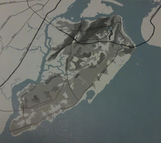
characteristics of what eventually became Geographical Information Systems (GIS). In his book he explores the layers of the region and how each piece should be used. One chapter of the book discusses Staten Island, one of the areas of New York hit hardest by the hurricane. In his book he dissects the ecological and man-made features of the island, ultimately leading him to define the areas that are most and least suitable to urbanisation.
 |
| Areas suitable for urbanisation (McHarg, 1969) |
The interesting comparison arises when you explore a map of the hurricane evacuation area (orange) on Staten Island and McHarg’s map of areas he deems unsuitable to urbanisation (dark areas) you find that by and large the two areas match up.
 |
| Evacuation zones (New York City, 2012) left and Areas unsuitable for urbanisation |
Events such as Hurricane Sandy demonstrate what some regional planners have long known, that it is important to design with nature.
