Spatial Inequality in the Smart City – Does increasing smartness lead to increased inequalities?
The Spatial Inequality in the Smart City project, funded by The Alan Turing Institute, highlights the potential of smart cities increasing rather than reducing observed spatial inequalities. The backbone of Smart City infrastructures are digital technologies, such as sensors, that are embedded into the physical fabric of cities. Unequal sensor deployments run the risk of creating ‘sensor deserts’, whereby some localities are not represented in the sensor data and therefore their issues may be invisible to those making decisions. To address this, the primary goal of this project is to produce practices that assist city authorities to approach sensor placement from an equity perspective, using intuitive tools that facilitate negotiating trade-offs across coverages, costs, and approaches. The pilot project is currently operating from Newcastle and Gateshead Local Authorities, UK.
Newcastle upon Tyne and Gateshead, UK. © Shutterstock netsign33
Approaches to air quality sensor placement in the North of England
City councils have a statutory responsibility to monitor air quality as it is linked with health outcomes. The UKCRIC (UK Collaboratorium for Research on Infrastructure and Cities) project aimed to establish a network of Urban Observatories, designed to collect data to improve the quality of life for residents. We investigated the different approaches taken to monitor air quality in cities in the North of England (Newcastle upon Tyne, Manchester, Sheffield, and Hull) through engagement with decision makers in Urban Observatories and Local Authorities.
We found that primary approaches to sensor placement were based on research objectives and requests by the community and local authority. Some initially deploy a sparse city-wide air quality monitoring network. Others are specifically linked to areas of change in the city, such as building works and new infrastructure development. The Local Authorities in cities that have an Observatory work closely with them, perhaps prioritising areas and engaging with communities but leaving the deployment decisions to the Observatory. However, some Local Authorities without an Observatory proactively establish LoRaWAN (Long Range Wide Area) networks to enable future sensor placement and data collection. They place sensors and combine existing data streams (traffic, weather, health etc) to create a holistic response network to benefit residents.
We also found the community groups who request sensors are often the loudest in their advocacy, not necessarily those who would most benefit from an air quality sensor. This tends to be in more affluent areas where residents have both the time and know-how to advocate for themselves and their communities. However, community initiatives (such as WeCount, SenseMyStreet and Connected Humber) have an important role to play in showing the value of air quality sensors as a community asset, rather than a tool of surveillance.
We also explored the different types of sensor coverage – population, spatial and data. Spatial coverage is defined by the range of the sensor, and data coverage is how much time the sensor is transmitting data. However, population coverage is harder to define – it is thought of as the ‘satisfaction’ of feeling covered by a sensor. Mostly spatial and data coverage are considered when placing sensors, but population coverage is the missing component.
Supporting decision makers in equitable technological placement
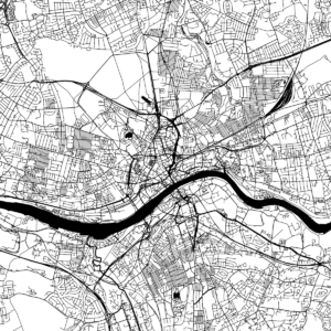
We developed a decision support tool to bring together data in a systematic way to assist in decision making. The tool combines spatial data and algorithmic optimisation to suggest networks that fulfil population coverage criteria to address unconscious or conscious inequity in smart city developments. Users are provided a visual framework that facilitates designing “optimal” sensor networks, whilst also considering coverage goals and necessary trade-offs.
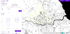
Figure 1 – Example sensor network generated by the decision support tool.
The current pilot decision support prototype has the capacity to view population characteristics for Newcastle and Gateshead Local Authorities and includes age, disability, the Index of Multiple Deprivation, and an exploratory space syntax analysis of the street network to proxy for traffic congestion. Our prototype allows a user to submit a scenario to the sensor placement optimisation which can include both single objective (one of the demographic variables), and multi-objective (compromising between several demographic variables) approaches. The results demonstrate the significant trade-offs in balancing different priorities, for example, increasing coverage of workplaces necessarily requires reducing coverage of older persons due to their different locations in the city.
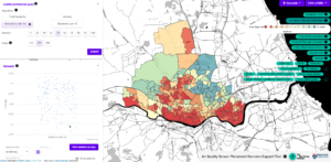
Figure 2 – Possible data that can be displayed from tool
Equitable air quality monitoring networks – A way forward?
We propose that the equitable coverage of populations is the missing component in smart city technological distribution and deployment. We also propose that the optimal way to fulfil statutory obligations is the deployment of a sparse, equitably distributed city-wide air quality network. Taking demographics and population coverage into account can ameliorate issues around non-representative information being used in decision making. We encourage a collaborative strategic approach, combining expertise from research, local knowledge of councillors and community engagement, specifically those who have not previously engaged in sensor placement.
There will always be trade-offs in coverage; we do not have an unlimited budget or number of sensors. Viewing trade-offs and accepting the complexity of technological distribution is important for informed decision making. Being aware of these issues is the first step in deploying equitable air quality monitoring networks – the exacerbation of existing inequalities is not inevitable!

Eman Zied’s (Twitter: @EZieD_) research focuses on urban planning, quantifying the city and evidence-based decision-making support. Eman’s research interests include the complex interplay between social, spatial, and digital inequalities, as well as how cities’ spatial structure can influence mobility and access to opportunities such as green space, jobs, schools, and amenities. She is currently part of the Spatial Inequality and the Smart City project, funded by The Alan Turing Institute. Her role focuses on the development of a decision-making support tool for equitable sensor placement, which involves engaging with stakeholders to find their priorities for the tool and spatial analysis of the city to inform decision making.
Dr. Eman Zied would also like to acknowledge the contributions of the research team, below. Dr. Kate Court (top left), Professor Rachel Franklin (top right), Dr. Caitlin Robinson (bottom left), and Dr. Jack Roberts (bottom left).

Are you currently involved with regional research, policy, and development? The Regional Studies Association is accepting articles for their online blog. For more information, contact the Blog Editor at rsablog@regionalstudies.org.